Gunung Datuk - What's the real height of Gunung Datuk ?
15 May 2010 - Gunung Datuk (655m / 870m) is located in Negri Sembilan which is about 3-4hrs drive from Singapore.
We started our journey the night before at 11pm and we arrived at the park at 4am. As it was still dark then, we had to sleep in the van to wait for the sunrise. I am not a person who can sleep easily in coaches or buses when travelling longer distances. Sleeping in the van was impossible.
Calvin was snoring to my left, Mathias was making weird noises to my right and the driver was also snoring. Calvin didn't have a good sleep either, when he snored too loud (which was quite often), i will elbow him and quickly look away hehe.

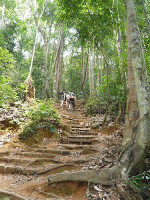
We started the trek at 7am when it became bright enough. We were immediately confronted with a steep and rocky ascend when we got into the trail.


There were also lots of roots and the soil was soggy and muddy in certain areas, probably due to the rain from the night before.


I must have sweated tons and thoughts of "why the hell did i sign up for this" cropped up numerous times during the first hour. Personally, the first hour was the toughest ! The steep and rocky terrain made it very difficult to climb. Perhaps the lack of sleep also played a part. Maybe i was also going too fast as i was following the pace of the trek leader then.
As i couldn't keep up with the leaders, i had to slow down. At a slower pace, I began to chat with the other trekkers and begin to notice the lush nature around me...

that's me holding on to a giant millipede

Leech on Jo's Ankle. (No Bite !)
Jo caught a leech and placed it on her ankle for it to suck the blood out from an old wound that was not healing properly. Even though the leech had a free blood meal, it refused to bite ! She said that it was properly due to the oil in her blood. Others said that her blood wasn't sweet and fresh enough.. hahaha.
If you ever go Gunung Datuk, you should be very happy when you see this boulder as you are getting very near to the "base camp" !


Bottles on ropes warning trekkers of the steep drop hidden by the foliage.
I made it to base camp ! Unbelievable ! I am now just a few big boulders away from the summit. By now, i am totally drenched in sweat. I could have jumped into a river with my clothes on and still be drier than what I am now.

"Base camp" - Camping Grounds
To get to the summit, we had to overcome a series of huge boulders, using tree roots and rusty ladders.


Although some of the trekkers had some problems climbing up the boulders, I enjoyed scaling the boulders. haha... It was probably the easiest and most enjoyable part of the climb for me :-)


SK enjoyed the climb up too !

Tight Squeeze ....
The view from the summit was simply breathtaking. The wind was cool and refreshing !


chilling out at the summit after an arduous 2 hrs hike !

We made it to the summit !
Going down took almost as long as going up. Some even found it tougher than the ascend ! Perhaps it was tiredness or the steepness of the descend. For me, I had no such issues. I was more than happy to use gravity to bring myself down the mountain haha. I've always enjoyed going downhill :-)
I learned two important lessons from this trip: 1) Always go at your own pace and enjoy the hike. 2) Anything higher than this will probably require training and/or conditioning if you want to have an enjoyable trek. That i intend to do ;-)
I learned two important lessons from this trip: 1) Always go at your own pace and enjoy the hike. 2) Anything higher than this will probably require training and/or conditioning if you want to have an enjoyable trek. That i intend to do ;-)
The real height of Gunung Datuk
On the way down, we met some locals who told us that the "boulder" summit (where we were just now) wasn't the highest point in Gunung Datuk. It was only about 655m. To verify their infomation, I took some photos of the "base camp" using my iphone. When you take a photo, iphone stores the GPS location data (latitude and longtitude) into the photo's exif data.

photo taken using iphone
In the exif data, the coordinates are 2.5505000000, 102.1826666667. When you plot the coordinates in Google maps ...


Click on the photo to see an bigger sized screen shot
To my disappointment, the locals were right ,*sob sob* I have only gone up to 655m ! You can see from the screen shot above that the real summit is about 1.5 km from where the boulders are.
I must get to the real summit one day !


You drove all the way from Singapore just to climb Gunung Datuk? WOW! Crazy. Actually early this year 3 of my friends from Singapore did exactly just that. I thought it was crazy, but then it was a good thing they did too because we were going to climb Mt Kinabalu and climbing Gg Datuk was part of the training climb that we all had to participate to gauge our fitness level.
ReplyDeleteMy friends are going to Mt Kinabalu again this September and we have 4 training climbs from now till then. IF you want to join us for the training climbs just write you email on my blog.
Eunice
Hi Eunice, we plan to go KK eventually... but the date hasn't been fixed. Will definitely be interested in joining your future hikes. Do let me know or update your blog. I am a follower of your blog :-)
ReplyDeleteLOL... okay. I haven't updated my blog since the Nuang trip in January. I will eventually continue blogging, but only after June. :) I will post up the training climb dates at the side bar. Just write to me on my chat screen if you have any questions or whatever. :)
ReplyDeleteIsn't Gunung Ledang nearer? AND higher?
ReplyDelete